Hokkaido, the northernmost of Japan’s main islands, is known for its volcanoes, natural hot springs (onsen) and ski areas. Rugged Daisetsuzan National Park is home to steaming, volcanic Mount Asahi. Shikotsu-Tōya National Park contains caldera lakes, geothermal springs and a Mount Fuji look-alike, Mount Yōtei. Popular ski resorts include Rusutsu, Furano and Niseko. With its unspoiled nature, many national parks and rural landscapes, Hokkaido attracts many outdoor lovers, including skiers and snowboarders in the colder seasons and hikers, cyclists and campers from June to September.
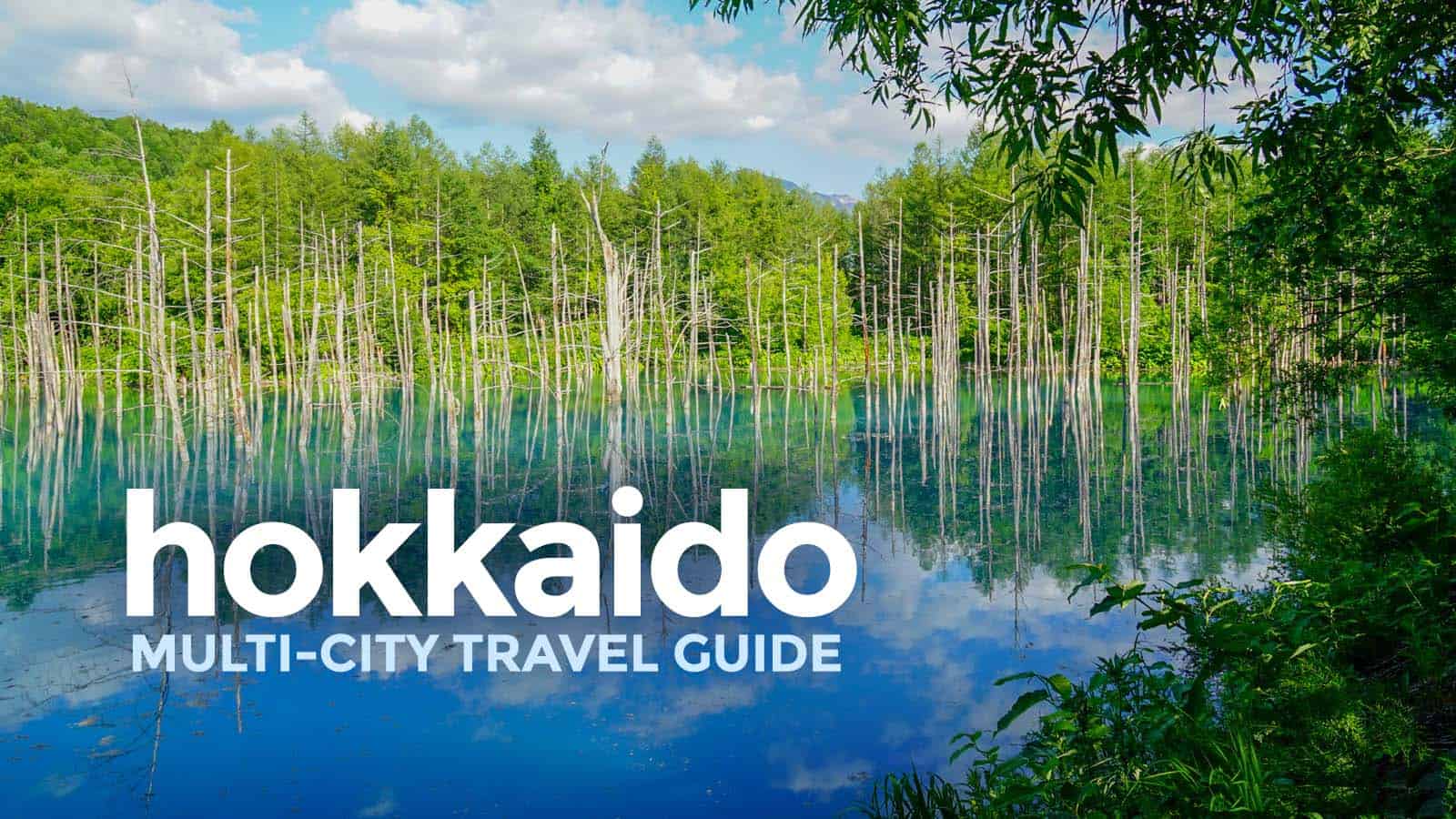
Shirogane Blue Pond
Shirogane Blue Pond is a man-made pond feature in Biei, Hokkaido, Japan. It is the result of works on the Biei River, carried out after the 1988 eruption of Mount Tokachi, to protect the town of Biei from volcanic mudflows. The colour is thought to result from the accidental presence of colloidal aluminium hydroxide in the water. Damage caused by Typhoon Mindulle in August 2016 resulted in a temporary drop in the water level and in the colour briefly turning brown with mud and sand from the Biei River.
Shiretoko National Park
Shiretoko National Park covers most of the Shiretoko Peninsula at the northeastern tip of the island of Hokkaidō, Japan. The word "Shiretoko" is derived from an Ainu word "sir etok", meaning "the place where the earth protrudes". One of the most remote regions in Japan, much of the peninsula is only accessible on foot or by boat. Shiretoko is best known as the home of Japan's largest brown bear population and for offering views of Kunashiri Island, ownership of which Japan and Russia dispute. Shiretoko is also the home of many birds, such as Steller's sea eagle and white-tailed eagle, and marine animals such as spotted seal, orca whale, and sperm whale. The park has a hot springs waterfall called Kamuiwakka Falls. Kamui wakka means "water of the gods" in Ainu. The forests of the park are temperate and subalpine mixed forests; the main tree species include Sakhalin fir, Erman's birch and Mongolian oak. Beyond the forest limit there are impenetrable Siberian dwarf pine thickets. In 2005, UNESCO designated the area a World Heritage Site, advising to develop the property jointly with the Kuril Islands of Russia as a transboundary "World Heritage Peace Park".
Lake Tōya
Lake Tōya is a volcanic caldera lake in Shikotsu-Toya National Park, Abuta District, Hokkaidō, Japan. It is part of "Toya Caldera and Usu Volcano Global Geopark" which joins in Global Geoparks Network. The stratovolcano of Mount Usu lies on the southern rim of the caldera. The lake is nearly circular, being 10 kilometers in diameter from east–west and 9 kilometers from north–south. The town of Tōyako comprises most of the area surrounding the lake and the town of Sōbetsu is located on the eastern side. Lake Tōya is said to be the northernmost lake in Japan that never ices, and the second most transparent lake in Japan. Nakajima Island is an island in the middle of the lake which houses the Tōya Lake Forest Museum. Lake Tōya was called Kim'un-to by the Ainu. In the Meiji era, Japanese pioneers named the lake Tōya after the Ainu expression to ya, which means "lakeshore, land around a lake." The 2008 G8 Summit was held at Lake Tōya and The Windsor Hotel Toya Resort & Spa.
Lake Akan
Lake Akan is a lake in Kushiro, Hokkaidō, Japan. It is located in Akan National Park and is a Ramsar Site.
Lake Shikotsu
Lake Shikotsu is a caldera lake in Chitose, Hokkaidō, Japan. It is a part of the Shikotsu-Toya National Park.
Asahi-dake
Mount Asahi or Asahi-dake is a mountain located near the town of Higashikawa, Hokkaido and the tallest mountain on the Japanese island of Hokkaido. It is part of the Daisetsuzan Volcanic Group of the Ishikari Mountains, it is located in the northern part of the Daisetsuzan National Park. Its native Ainu name is Kamui-mintara, which means "the playground of the gods". The mountain is popular with hikers in the summer and can be easily reached from Asahidake Onsen via Asahidake Ropeway. During winter, the mountain is open for use by skiers and snowboarders. Sugatami Pond, directly below the peak, is famous for its reflection of the peaks, snow, and steam escaping from the volcanic vents.
Lake Shikotsu
Lake Shikotsu is a caldera lake in Chitose, Hokkaidō, Japan. It is a part of the Shikotsu-Toya National Park.
Farm Tomita
Farm Tomita is a farm in Nakafurano, Hokkaido, Japan. Farm Tomita is one of the many farms in the area which create this reputation by planting giant fields of lavender and other colorful crops such as tulips. Right, is a picture of one of the many scenic vistas available to tourists who visit the farm. The farm also sells many products based on the lavender it produces, from lavender scented candles and soap to lavender flavored drinks and ice cream
Mount Hakodate
Mount Hakodate is a mountain in Hakodate, Hokkaidō, Japan. The mountain is renowned for its view of the surrounding bay and city. The Michelin Green Guide: Japan gave the experience 3/3 stars in a review, placing it as equal to mountain views of Naples and Hong Kong. The peak is accessible by hiking or by bike, as well as by a regular cable car service.
Lake Mashū
Lake Mashū is an endorheic crater lake formed in the caldera of a potentially active volcano. It is located in Akan Mashu National Park on the island of Hokkaidō, Japan. It has been called the clearest lake in the world.
Daisetsuzan National Park
Daisetsuzan National Park, or Taisetsuzan is located in the mountainous center of the northern Japanese island of Hokkaidō. At 2,267.64 square kilometres, Daisetsuzan is the largest national park in Japan, and is approximately the size of Kanagawa Prefecture. Daisetsuzan, meaning "great snowy mountains", an apt description of these peaks. There are 16 peaks over 2,000 metres in Daisetsuzan National Park, both with and without trails. The park offers some of the most rugged scenery in Japan. Asahidake, located in the north of the park, is the highest peak in Hokkaidō. Daisetsuzan National Park spans two subprefectures of Hokkaidō, Kamikawa and Tokachi. Daisetsuzan National Park was established in 1934.
Daisetsuzan Volcanic Group
The Daisetsuzan Volcanic Group is a volcanic group of peaks arranged around the 2 kilometres wide Ohachi-Daira caldera in Hokkaidō, Japan. In the Ainu language it is known as Nutapukaushipe, Nutaku Kamushupe, or Optateske. These peaks are the highest in Hokkaidō. The group lends its name to the Daisetsuzan National Park in which the volcanic group is located.
Mount Yōtei
Mount Yōtei is an active stratovolcano located in Shikotsu-Toya National Park, Hokkaidō, Japan. It is also called Yezo Fuji or Ezo Fuji, "Ezo" being an old name for the island of Hokkaido, because it resembles Mount Fuji. The mountain is also known as Makkari Nupuri and Mount Shiribeshi. It is one of the 100 famous mountains in Japan.
Jigokudani
Jigokudani or "Hell Valley" is a spectacular, appropriately named valley just above the town of Noboribetsu Onsen, which displays hot steam vents, sulfurous streams and other volcanic activity. It is a main source of Noboribetsu's hot spring waters.
Lake Kussharo
Lake Kussharo is a caldera lake in Akan National Park, eastern Hokkaidō, Japan. As with many geographic names in Hokkaidō, the name derives from the Ainu language. It is the largest caldera lake in Japan in terms of surface area, and sixth largest lake in Japan. It is also the largest lake in Japan to freeze over completely in winter. The name Lake Kutcharo is also sometimes used. The lake’s central island, Nakajima, is a stratovolcano. Volcanic gases render the lake water acidic, and it supports few fish except in areas where inflowing streams dilute the water. Rainbow trout, which are also resistant to fairly acidic water, have been artificially introduced. In 1951, a rare form of cicada was discovered, and is now protected by the government. The lake is also on the migratory path of the whooper swan. Along the lake shore are several outdoor hot springs and a sand beach with naturally heated sand and hot ground water. Wakoto Peninsula extending into the lake has a number of active sulfurous vents. The lake is also known as Japan's Loch Ness, after numerous reported sightings on a lake monster dubbed Kusshii by the press from 1973.
Shikisai No Oka
Shikisai no Oka (Four Seasons Hill) is a flower garden on a hill carpeted with flowers from April to October. This feast for the eye features tulips, lupine, lavender, salvia, sunflowers, dahlia and Japanese anemone.
Takino Suzuran Hillside
Takino Suzuran Hillside National Government Park is a Japanese national government park located in Sapporo, Hokkaido. It is the only national government park in the northern island of Hokkaido. The park area spreads over 395.7 hectares of hilly country and ranges in altitude between 160 and 320 m above sea level. Currently, 192.3 is accessible to the public. The park grounds are separated into six zones: the Mountain Stream Zone, Central Zone, Lodging Zone, Forest Experience Zone, Nature Observation Zone, and Preservation Zone. During the winter season, the park operates as the “Takino Snow World”, providing visitors with a wide variety of winter outdoor activities.
Kushiro-Shitsugen National Park
Kushiro-Shitsugen National Park is a national park located in the east of the island of Hokkaido, Japan. It was designated as a national park on 31 July 1987. The park is known for its wetlands ecosystems. Kushiro-shitsugen covers an area of 268.61 square kilometres on the Kushiro Plain and contains the largest tracts of reedbeds in Japan. The Kushiro River, which originates in Lake Kussharo, meanders through much of the park. During the Ramsar Convention of 1980, in which Japan participated, the park was first registered as a peatland with raised bogs. In 1967, the wetlands themselves had been designated as a national natural monument. For that reason, access is strictly limited and the landscape, most typical of Hokkaido, has been preserved.
Mount Rishiri
Mount Rishiri is a Quaternary stratovolcano located off the coast of Hokkaidō, Japan in the Sea of Japan. It rises out of the Sea of Japan forming Rishiri Island. Because its cone shape resembles Mount Fuji it is sometimes referred to as Rishiri Fuji. It is one of the 100 famous mountains in Japan. Mount Rishiri's opening festival is held annually on July 2 and July 3. This festival officially opens the climbing season.
Shirahige Waterfall
Shirahige Waterfall ‘White Beard Waterfall’ sits in the center of Japan’s most northern Prefecture, Hokkaido, on the outskirts of the small town Biei at an altitude of 600m above sea level. Water flows down the side of the mountain side, and feeds into the small Blue River, which flows into the scenic blue river, both visible from the Blue River Bridge. The water gets it’s blue colour from a mixture of the fresh mountain water, and the sulfuric content of the water, as the surrounding area is thermally active with an Onsen resort being only a short distance away.
Lake Notoro
Lake Notoroalso Lake Notori or Notoro Lagoon, is a coastal lagoon by the northern shore of Abashiri, Hokkaidō, Japan. It is included in Abashiri Quasi-National Park. It is the 13th-largest lake in Japan. It is about 2 km northwest of Lake Abashiri and 15 km east of Lake Saroma.
Shōwa-shinzan
Shōwa-shinzan is a volcanic lava dome in the Shikotsu-Toya National Park, Hokkaido, Japan, next to Mount Usu. The mountain was created between 28 December 1943 and September 1945. Initially, a series of strong earthquakes shook the area, and wheat fields were rapidly uplifted. Lava broke through the surface and the current peak was created. The peak is now 398 m tall, and still actively smoking. The name Shōwa-shinzan means "Shōwa new mountain", as it formed during the reign of Emperor Hirohito, known as the Shōwa period. When Shōwa-shinzan first appeared, the Japanese authorities were worried that it might be interpreted as an unlucky wartime omen, and its existence was kept secret. Much of the information about peak's formation during these years comes from local postmaster Masao Mimatsu, who kept detailed measurements of its progress.